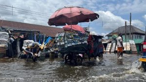
Port Harcourt — People wade through fast-flowing water, holding one another to avoid being swept away, balancing suitcases, clothing and food on their heads.
The torrent was, until recently, the East-West Road in Nigeria’s Rivers state, the gateway to the nation’s oil and gas.
Now parts of Rivers, along with large swathes of 32 other states, are inundated by the worst flooding in 12 years.

“We cannot access Ahoada West anymore,” local government chairman Hope Ikiriko said of the area he represents. He said 30 boats were helping to move people to camps built to accommodate the area’s 150,000 displaced.
“We are going to rescue people who hitherto never wanted to quit,” he added.
Nigerian authorities said Rivers, Anambra, Delta, Cross River and Bayelsa states remain at risk of flooding until the end of November.
The flooding has killed more than 600 people, displaced around 1.4 million and damaged or destroyed 440,000 hectares of farmland. Health officials warn it could worsen an ongoing cholera outbreak, and even natural gas exports are at risk.
Authorities blame heavy rains and a water release from the Lagdo dam in Cameroon. Experts say global warming, and poor planning, worsened the disaster.
“Climate change is playing a big role in this,” said Hiba Baroud, associate professor of civil and environmental engineering at Vanderbilt University. “But the other component is…the vulnerability of the infrastructure. This is how we end up in a disaster like this one.”
The 2021 Notre Dame Global Adaptation Index ranked Nigeria among the bottom 20 nations in its readiness to adapt to climate change.
Baroud said a Nigerian dam meant to backstop Cameroon’s Lagdo was planned, but never completed. A lack of zoning allows houses in flood zones and poor irrigation places farmers at the edge of rivers that can inundate their fields.
“It’s going to have cascading effects on diseases, on food security and so on,” Baroud said.
*Angela Ukomadu, Camillus Eboh & Libby George, editing: Ed Osmond – Reuters
Follow us on twitter


